Katata and Ukimido Floating Temple 堅田・浮御堂
|
Title   • File Name • File Name   • Date • Date   • Position • Position   |
|

Entrance to Ukimido Floating Temple, which is actually Mangetsu-ji temple. Admission is 300 yen. Hours: 8 am - 5 pm. Buses run from Katata Station. Parking available. 満月寺 浮御堂 MAP
|
|

Ukimido floating temple in Katata, one of Shiga's most famous and picturesque buildings. One of the eight Omi Hakkei Views made famous by ukiyoe prints by Hiroshige.
|
|

The scenic Ukimido has been the subject of ukiyoe woodblock prints (see below) by Hiroshige and other artists. You can walk on the short bridge to the Ukimido.
|
|

The Ukimido building itself has been rebuilt a few times over the centuries. It was first built in the 10th century by Priest Eshin (Genshin 源信) from Enryakuji temple on Mt. Hiei. The current temple building was built in 1937 and renovated in 1982.
|
|
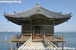
View from the bridge to Ukimido Floating Temple, Katata, Shiga. The building houses altars and 1,000 small Amida Buddha figures supposedly carved by Priest Enshin. Dedicated to transportation safety on the lake.
|
|

View from the balcony.
|
|

Bridge from shore
|
|
|

Balcony looking toward Lake Biwa
|
|

Concrete stilts reinforce the wooden stilts.
|
|

Balcony facing the lake.
|
|

View of Lake Biwa from Ukimido. The Biwako Ohashi Bridge can be seen in the distance.
|
|

Altar facing the lake.
|
|

Altar facing the lake, with some of the 1,000 Amida Buddha figures.
|
|

Altar facing the shore
|
|

North side of Ukimido. Haiku poet also visited Ukimido and wrote a haiku poem about it, displayed on a stone monument on shore.
|
|

Ukiyoe woodblock print by Hiroshige showing "Descending Geese at Katata" with Ukimido in the foreground. 近江八景「堅田の落雁」
|
|
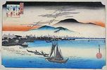
Another ukiyoe woodblock print by Hiroshige showing "Descending Geese at Katata" with Ukimido in the background. 近江八景「堅田の落雁」
|
|

Concrete stilts. Compare this with the next postcard image.
|
|
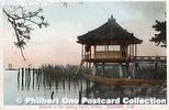
Vintage postcard of Ukimido floating temple before 1937 when the building was rebuilt. Flimsy stilts in comparison.
|
|
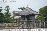
Ukimido as seen from the lake.
|
|

View of Ukimido while rowing on Lake Biwa.
|
|

Bench on shore near Ukimido
|
|

Mt. Mikami in the distance.
|
|

JR Katata Station on the JR Kosei Line along the western shore of Lake Biwa, Shiga. Local buses run to Ukimido and other places. There's also a bus which crosses the Biwako Ohashi Bridge to reach Moriyama on the other side. 堅田駅
|
|

Biwako Aika (Lake Biwa Elegy) Monument and memorial for songwriter Okuno Yashio who was from Katata. Details about the song here. 琵琶湖哀歌の歌碑 堅田
|
|

Biwako Aika 琵琶湖哀歌 (Lake Biwa Elegy) is a mournful song dedicated to the eight college rowers from Kanazawa, Ishikawa Prefecture and three rowers from Kyoto who died while practicing in waters off Takashima-cho, Haginohama beach when struck by st
|
|

The accident occurred on April 6, 1941. The boys from Kanazawa were students at the No. 4 High School 第四高等学校 which today is Kanazawa University. The sad incident spurred Okuno to create this song.
|
|
|
|
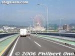
Biwako Ohashi Bridge is 1.35 km long connecting Moriyama and Katata across the neck of Lake Biwa.Biwako Ohashi Bridge also has a "melody road" with grooves on a 600m stretch of the bridge. When you drive over it, you can hear the melody for Biwako Shuko no Uta (Lake Biwa Rowing Song).
|
|
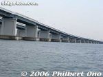
Biwako Ohashi Bridge also has a "melody road" with grooves on a 600m stretch of the bridge. When you drive over it, you can hear the melody for Biwako Shuko no Uta (Lake Biwa Rowing Song).
|
|
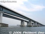
Biwako Ohashi Bridge
|
|
|
|
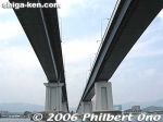
Under Biwako Ohashi Bridge
|
|
|
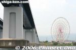
This giant ferris wheel was a landmark in Katata until it was finally dismantled.
|
|
|
|
|
|
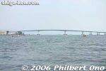
Biwako Ohashi Bridge is Shiga's longest bridge.
|
|
|
|
|
|
|
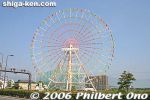
The giant ferris wheel was a remnant of the Biwako Tower amusement park that had long closed.
|
|
|
|
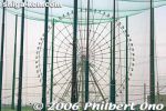
Golf practice range in Katata.
|
|
|
|
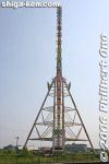
Ferris wheel front view.
|
|

Michinoeki Biwako Ohashi Kome Plaza, a shopping place for local produce. 道の駅びわ湖大橋米プラザ
|
|

Inside Biwako Ohashi Kome Plaza. "Kome" means rice. On the first floor they sell local rice and produce.
|
|

Also on the 2nd floor is an information room about Lake Biwa and Shiga.
|
|
|

Omi rice made in Shiga.
|
|

Biwako Ohashi Bridge as seen from Biwako Ohashi Kome Plaza in Katata. 琵琶湖大橋
|
|

The Biwako Ohashi Bridge spans the neck of Lake Biwa's panhandle between Moriyama and Katata, the lake's narrowest width. Completed in Sept. 1964, the bridge portion over the lake is 1.4 km long.
|
|

Biwako Ohashi Bridge is a toll road (200 yen for ordinary passenger cars), but free for bicycles and pedestrians who can go on the sidewalk. There are actually two parallel bridges, making it a four-lane bridge. The additional bridge was built in 1994.
|
|

Biwako Ohashi Kome Plaza facing the lake. It also has a lookout deck on the 2nd floor.
|
|

Biwako Ohashi Kome Plaza lookout deck on the 2nd floor.
|
|
|
|

Biwako Ohashi as seen from the lookout deck on the 2nd floor. The bridge makes it almost 50 min. faster to go to the other side of the lake.
|
|

About Biwako Ohashi Bridge.
|
|

The hump at the center is about 26.3 meters above the lake surface allowing boats to pass under. If you bicycle around Lake Biwa, you can cross this bridge as a short cut. But I recommend cycling all the way down to central Otsu.
|
|

With twin two-lane bridges, the 1.4-km north bridge (Katata to Moriyama traffic) was completed in 1994. The south bridge (1.35 km) was the original bridge completed in 1964 (for for Moriyama to Katata traffic).
|
|

Bridge traffic is well over 30,000 vehicles per day.
|
|

Katata pier
|
|
|
|
|