 Last additions - Takashima 高島市 Last additions - Takashima 高島市 |

Imagine having a spring in your own home spewing drinkable water 24/7 for free. This kabata has a few baskets. The oblong one is used for fish, and the ones on the right were used to dry bowls.May 18, 2009
|
|

Harie Okawa River has baikamo underwater flowers. It was muddy when I visited in late April because of the rice paddy flooding. 針江大川May 18, 2009
|
|

Sign saying that you are entering Harie where water is a treasure. The important thing to understand about Harie is that you need a guide to see the kabata water springs in private homes.May 18, 2009
|
|

The guided tour is well worth it. I highly recommend it. The Harie-Okawa River would be crystal clear if it weren't for the rice paddies being flooded. MAPMay 18, 2009
|
|

In 2014, The Shozu-no-Sato Committee 針江生水の郷委員会 won the top Ecotourism Grand Prize エコツーリズム大賞 sponsored by the Japan Ecotourism Society and Environment Ministry. Harie Hiyoshi Jinja Shrine 針江日吉神社May 18, 2009
|
|

When I visited Harie in late April, the water, which supposed to be crystal clear, was muddied from the rice paddies being drained. Late April to June is probably not a good time to visit Harie due to the rice paddies.May 18, 2009
|
|

May 18, 2009
|
|

This is the first kabata we visited. There is a pipe which spews the spring water from 12 to 25 meters below the ground. The original water source is called moto-ike.May 18, 2009
|
|

May 13, 2009
|
|

Makino Pic-landMay 13, 2009
|
|

Putting golf course during non-winter months.May 13, 2009
|
|

Attached lake in Makino in winter.May 13, 2009
|
|

Makino Highland. MAPMay 13, 2009
|
|

Makino in winterMay 13, 2009
|
|

Map of Makino Highland. Quite a large area.May 13, 2009
|
|

Makino manhole, Takashima, Shiga Pref.May 13, 2009
|
|

Makino Highland is quite large, includes a small skiiing ground and hiking trails to a waterfall. A great place to relax to get away.May 13, 2009
|
|

May 13, 2009
|
|

Yae-zakura cherry blossoms in late April in Makino Highland in Takashima.May 13, 2009
|
|

Yae-zakura cherry blossoms are fluffy-looking.May 13, 2009
|
|

May 13, 2009
|
|

Onsen hot spring facility in Makino Highland.May 13, 2009
|
|

River in Makino Highland.May 13, 2009
|
|

May 13, 2009
|
|

May 13, 2009
|
|

Another noted sight of Makino is this neat row of Metasequoia (dawn redwood) trees. MAPMay 13, 2009
|
|

May 13, 2009
|
|

Entrance to Makino Highland (Makino Kogen). Free admission. マキノ高原May 13, 2009
|
|

There's a walking path along both sides of the trees.May 13, 2009
|
|

May 13, 2009
|
|

May 13, 2009
|
|

Metasequoia (dawn redwood) trees on the way to Makino Highland.May 13, 2009
|
|

May 13, 2009
|
|

Road to Makino Highland. From here, it's an upward slope (if you're bicycling). Not too bad though. Otherwise, take a bus from Makino Station.May 13, 2009
|
|

Makino Station is the closest station to Kaizu-Osaki in northern Lake Biwa. Famous for cherry blossoms in mid-April. Best to rent a bicycle at Makino Station. Kaizu-Osaki photos here.May 13, 2009
|
|

May 13, 2009
|
|

On the west side of Makino Station, you can visit Makino Highland. I went by bicycle.May 13, 2009
|
|

KaizuMay 13, 2009
|
|

Makino Sunny Beach looks best on a sunny day...May 13, 2009
|
|

Several hundred meters of stone wall was built in the early 18th century along the lake shore to prevent high waves from damaging homes.May 13, 2009
|
|

Kaizu stone wall is what you see along the way to Kaizu-Osaki on the distance.May 13, 2009
|
|
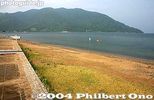
Makino Sunny Beach is a major swimming beach on Lake Biwa in summer. MAPMay 13, 2009
|
|

Makino Sunny BeachMay 13, 2009
|
|

May 13, 2009
|
|

Monument for Takagihama beach.May 13, 2009
|
|

Makino Sunny Beach is a major swimming beach on Lake Biwa in summer.May 13, 2009
|
|

Map of Makino. Makino used to be an independent town until it merged with neighboring towns to form the city of Takashima.May 13, 2009
|
|

Right across Makino Station is this building which houses the local tourist information office. This is where you can rent a bicycle and obtain sightseeing maps.May 13, 2009
|
|

Makino Station looking from the west. Very little development on this side of the station.May 13, 2009
|
|

In spring when the cherry blossoms bloom at Kaizu-Osaki, a makeshift food stall is setup outside Makino Station selling local foods.May 13, 2009
|
|

Makino Station platform in winter. This was in Jan. 2006.May 13, 2009
|
|
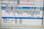
Diagram showing how many minutes it takes to go from Makino Station to other stations. Around 68 min. to/from Kyoto and 32 min. to Omi-Takashima. Makino is also accessible from Maibara via Omi-Shiotsu Station.May 13, 2009
|
|

Kosei Line train going to Makino Station.May 13, 2009
|
|

Old-style train on Kosei Line at Makino Station.May 13, 2009
|
|

Makino is only one of two towns in Japan whose name uses katakana (the other is Niseko in Hokkaido). マキノ町May 13, 2009
|
|

Makino Station corridor with a photo showcase.May 13, 2009
|
|

Makino Station turnstile/gateMay 13, 2009
|
|

Makino Station. Makino was the first town in Japan whose name used katakana. The town was established in 1955 upon the merger of a few villages. The new town was named after its most famous spot, the Makino Ski Grounds which used katakana for "MakinoMay 13, 2009
|
|
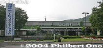
Makino Station on the JR Kosei Line. The only train station in the Makino area of Takashima. MAPMay 13, 2009
|
|

The original kanji for Makino was 牧野. However, the ski grounds used katakana to give an imported feel since skiing was imported back then in the 1920s. Photo: Makino Station's cherry trees.May 13, 2009
|
|

May 13, 2009
|
|

They run around the shrine with the mikoshi and shout.May 13, 2009
|
|

I never got to see the torches with the mikoshi. For more info, call the shrine in Japanese: 0740-28-0051May 13, 2009
|
|

One mikoshi arrives at Kaizuten Shrine.May 13, 2009
|
|

May 13, 2009
|
|

In front of a large crowd, they dramatically raise and lower the mikoshi.May 13, 2009
|
|

May 13, 2009
|
|

Unfortunately, I had to leave to catch the last train home (after 10 pm) before the climax ended.May 13, 2009
|
|

Another arrives at Kaizuten Shrine at about 9 pm.May 13, 2009
|
|

May 13, 2009
|
|

This was the climax of the Kaizu Rikishi festival.May 13, 2009
|
|

At Kaizuten Shrine, kids light their torches.May 13, 2009
|
|
|
|

They did this repeatedly until they went further up the shrine.May 13, 2009
|
|

These photos were taken from 5 pm so they look rather dark. If you want brighter photos, go during the day. But then, the festival climax is at night when they gather at the shrine.May 13, 2009
|
|

They wear kesho mawashi ceremonial aprons normally worn by sumo wrestlers. These aprons are possessed by local families and passed down to successive generations.May 13, 2009
|
|

Now the Kaizu mikoshi group starts their way at 5 pm. They go in the opposite direction (north) from the Nishihama group. 海津May 13, 2009
|
|

May 13, 2009
|
|
|

The festival started with a Shinto ceremony at the shrine with two mikoshi portable shrines present. Then at 1 pm, they left the shrine and carried the mikoshi in their neighborhoods.May 13, 2009
|
|

May 13, 2009
|
|

May 13, 2009
|
|

The two mikoshi portable shrines. They are carried by the two neighborhoods (Kaizu and Nishihama) during the day (1 pm - 3 pm) and in the evening. They rest from 3 pm to 5 pm.May 13, 2009
|
|

Three centuries ago, the Kaizu was a port for small cargo boats plying Lake Biwa to deliver goods from Hokuriku to Kyoto. Local young men working for these boats started sumo wrestling in the shrine and making these kesho mawashi aprons.May 13, 2009
|
|

May 13, 2009
|
|

Some local people come out to watch.May 13, 2009
|
|

The Kaizu mikoshi proceeds along the shore of Lake Biwa, heading toward Kaizu.May 13, 2009
|
|

May 13, 2009
|
|

Many of the aprons have a kanji character for dragon, tiger, or other macho themes.May 13, 2009
|
|

Rest break for Kaizu mikoshi.May 13, 2009
|
|

Marker showing the way to Kaizuten Jinja Shrine on a busy highway in Makino. Kaizuten Jinja holds the annual Kaizu Matsuri (nicknamed Kaizu Rikishi Matsuri) on April 29. Rikishi means sumo wrestler.May 13, 2009
|
|

The Nishihama (西浜) group go through their neighborhood along the shore of Lake Biwa. About 30 men carry the mikoshi.May 13, 2009
|
|

The festival started with these young men dressed like sumo wrestlers.May 13, 2009
|
|

At 5 pm, they started to carry the mikoshi again in their neighborhoods. This local festival features men dressed as sumo wrestlers (rikishi) carrying the two mikoshi portable shrines. This is the Nishihama group.May 13, 2009
|
|

May 13, 2009
|
|

May 13, 2009
|
|

They sometimes jostle the mikoshi up and down.May 13, 2009
|
|

May 13, 2009
|
|

The Nishihama mikoshi on its way to Kaizuten Shrine.May 13, 2009
|
|

Kaizuten Jinja. If you're walking from Makino Station, be careful as part of the highway along the way has no sidewalk. At night, bring a flashlight so the cars can see you. MAPMay 13, 2009
|
|

May 13, 2009
|
|

They shout "Yo-ya-sa-ja!." (ヨーヤサージャー). They take several rest breaks along the way.May 13, 2009
|
|

They are called the Kamogawa 48 Stone Buddhas. They were originally made in 1553 by Sasaki Rokkaku Yoshikata (佐々木六角 義賢), lord of Kannonji Castle in Azuchi in memory of his deceased mother.May 13, 2009
|
|

May 13, 2009
|
|

May 13, 2009
|
|

May 13, 2009
|
|

Originally, there were 48 stone buddhas. Only 33 remain now. Thirteen of them were moved to Sakamoto in Otsu, and 2 were stolen. Although they stand upright, it's possible that they can fall on you, especially if you've been bad.May 13, 2009
|
|

Haginohama Beach in Takashima.May 13, 2009
|
|

The sand is not as nice.May 13, 2009
|
|

May 13, 2009
|
|

May 13, 2009
|
|

May 13, 2009
|
|

Entrance to Haginohama Beach. 萩の浜May 13, 2009
|
|

May 13, 2009
|
|

Kamogawa Katsuno Enchi park in Takashima. 鴨川勝野園地May 13, 2009
|
|

This is close to Haginohama Beach.May 13, 2009
|
|

They also planted many cherry trees along the shore, but the trees recently died.May 13, 2009
|
|

May 13, 2009
|
|

A small stream empties into Lake Biwa through Haginohama Beach. Numerous streams and rivers like this one feed water to the lake.May 13, 2009
|
|

On the hillside between Omi-Takashima Station and Shirahige Shrine, there is a cemetery with 33 large stone buddhas. MAPMay 13, 2009
|
|

There was a green belt called Kamogawa Katsuno Enchi. It was basically a beach park.May 13, 2009
|
|

River mouthMay 13, 2009
|
|

Map of Shirahige Shrine.May 13, 2009
|
|

Shirahige-no-Hama Beach in Takashima. I know they did some filming here for the NHK Taiga Drama "Go" where she rides on horseback. 白ひげの浜May 13, 2009
|
|

The stone buddhas are about 1.6 meter tall, made of granite.May 13, 2009
|
|

Monument dedicated to the eight college rowers from Kanazawa, Ishikawa Prefecture and three rowers from Kyoto who died while rowing in waters off Haginohama beach on April 6, 1941..May 13, 2009
|
|

A small stream empties through Haginohama BeachMay 13, 2009
|
|

May 13, 2009
|
|

May 13, 2009
|
|

Shirahige-no-Hama Beach and Lake Biwa in Takashima, Shiga Prefecture.May 13, 2009
|
|

May 13, 2009
|
|

Entering Takashima-cho from Adogawa. (I was bicycling.)May 13, 2009
|
|

Shirahige Shrine's torii in Lake Biwa. The torii is a smaller version of the much more famous one in Miyajima (Itsukushima Shrine in Hiroshima Prefecture).May 13, 2009
|
|

Omizo Castle 大溝城May 13, 2009
|
|

Side view of Shirahige Shrine.May 13, 2009
|
|

May 13, 2009
|
|

They encountered strong winds from the Hira mountains. The boys from Kanazawa were students at the No. 4 High School 第四高等学校 which today is Kanazawa University.May 13, 2009
|
|

On top of the stone foundation. Not very well kept.May 13, 2009
|
|

In front of Omi-Takashima Station is a large Gulliver statue.May 13, 2009
|
|

Haiden on right and Honden on left.May 13, 2009
|
|

Inside the Haiden Hall of Shirahige Shrine. People also pray at the shrine for finding a good marriage partner, conceiving a child, academic excellence (passing college entrance exams), and water/boating safety.May 13, 2009
|
|

Next to Shirahige Shrine is Wakamiya Shrine, and more smaller shrines in the rear.May 13, 2009
|
|

This is to publicize the Gulliver Youth Travel Village, a camping and recreational facility. ガリバー青少年旅行村
May 13, 2009
|
|

Murasaki Shikibu poem monumentMay 13, 2009
|
|

Marker for Omizo Castle's San-no-Maru keep.May 13, 2009
|
|

Omi-Takashima Station and Kosei Line train.May 13, 2009
|
|
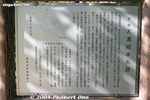
Sign about Omizo Castle.May 13, 2009
|
|

Giant statue of Gulliver outside JR Takashima Station.May 13, 2009
|
|

Side view of Shirahige Shrine.May 13, 2009
|
|

Omi-Takashima Station on the JR Kosei Line. Takashima's southern-most train station and the only train station in the Takashima-cho area. It takes about 38 min. from Kyoto. JR湖西線 近江高島駅 MAPMay 13, 2009
|
|
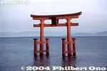
Shirahige Shrine torii, Takashima. One of Lake Biwa's best-known landmarks. It faces the shrine on land. Rent a bicycle or go by taxi from Omi-Takashima Station (Kosei Line).May 13, 2009
|
|

Haiden on left and Honden Hall on right.May 13, 2009
|
|

My bicycle. I once cycled around Lake Biwa, taking 3 days and two nights.May 13, 2009
|
|

A short walk from Omi-Takashima Station is Omizo Castle's patch of stone wall still remaining.May 13, 2009
|
|

Looking toward Lake Biwa.May 13, 2009
|
|

Omi-Takashima Station May 13, 2009
|
|
|
|

Pieces of concrete indicate that something was here before.May 13, 2009
|
|

Looking toward the lake from Shirahige Shrine.May 13, 2009
|
|

May 13, 2009
|
|

View from Omi-Takashima Station.May 13, 2009
|
|

Omizo Castle's Honmaru keep.May 13, 2009
|
|
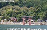
Off the shore of Takashima, with Shirahige Shrine's torii in the lake. "Shirahige" means white beard, and so people pray here for long life and longevity. The shrine is dedicated to a god named Sarutahiko. 白鬚神社May 13, 2009
|
|

Shirahige Shrine is Shiga's oldest shrine with regard to the founding date. 白鬚神社May 13, 2009
|
|

Shirahige Shrine faces a very busy road with no crosswalk to the lake. May 13, 2009
|
|

Matsuo Basho haiku monument.May 13, 2009
|
|

All that's left is this stone foundation of Omizo Castle.May 13, 2009
|
|

Omizo Castle in Takashima was originally built by Oda Nobuzumi in 1578, a nephew of Oda Nobunaga. It was built to oversee transportation on Lake Biwa along with Azuchi, Nagahama, and Sakamoto Castles on the shores of Lake Biwa.May 13, 2009
|
|

Off the shore of Takashima, with Shirahige Shrine's torii in the lake.May 13, 2009
|
|
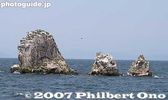
Also part of Adogawa is Okino-shiraishi Rocks, a few km off shore and a favorite place for birds which turned the rocks white from their droppings. Four rocks stand 80 meters deep in the lake. Out of the water, the tallest stands 14 meters high. 沖の白May 12, 2009
|
|

Japanese-style room in Chojiya ryokan. Very quaint and quiet place fronting the lake.May 12, 2009
|
|

Inside Chojiya. May 12, 2009
|
|

Inside Chojiya. Very impressive Japanese-style inn with lake views. This ryokan is also well-known for duck dinners.May 12, 2009
|
|

On Imazu's lakeshore road, Chojiya ryokan. From the roadside, it looks like a small building, but it has much depth toward the lake shore. 丁子屋May 12, 2009
|
|

They finally brought the O-nobori all the way across the Otabisho.May 12, 2009
|
|

May 12, 2009
|
|

May 12, 2009
|
|

Prayers in front of the mikoshi.May 12, 2009
|
|

Mt. Ibuki across Lake Biwa as seen from the Otabisho.May 12, 2009
|
|

Three community groups participate in Kawakami Matsuri. They rotate every year for taking care of the O-nobori, mikoshi, and sanyare dance and music.May 12, 2009
|
|

Children doing sanyare dance at Kawakami Matsuri.May 12, 2009
|
|

May 12, 2009
|
|

May 12, 2009
|
|

May 12, 2009
|
|

The mikoshi procession also arrived at the Otabisho.May 12, 2009
|
|

May 12, 2009
|
|

OtabishoMay 12, 2009
|
|

May 12, 2009
|
|

May 12, 2009
|
|

May 12, 2009
|
|

May 12, 2009
|
|

May 12, 2009
|
|

May 12, 2009
|
|

May 12, 2009
|
|

May 12, 2009
|
|

May 12, 2009
|
|

May 12, 2009
|
|

Then they had yabusame with horse runs down the Otabisho. No arrow shooting though.May 12, 2009
|
|

They paraded the mikoshi around the Otabisho.May 12, 2009
|
|

More yabusame.May 12, 2009
|
|

May 12, 2009
|
|

May 12, 2009
|
|

May 12, 2009
|
|

Then they slowly dragged the two O-nobori poles across the Otabisho.May 12, 2009
|
|

May 12, 2009
|
|

May 12, 2009
|
|

May 12, 2009
|
|

Standing up the O-nobori at the Otabisho during the Kawakami Matsuri in Imazu, Takashima. May 12, 2009
|
|

Children doing the sanyare dance at the Kawakami Matsuri in Imazu, Takashima. サンヤレ踊りMay 12, 2009
|
|

May 12, 2009
|
|

May 12, 2009
|
|

The O-nobori is now horizontal, carried by the people in the procession.May 12, 2009
|
|

The Kawakami Matsuri is also called the Sanyare Matsuri. The festival starts with a Shinto ceremony at both Hioki and Tsuno Shrines. This is Tsuno Shrine.May 12, 2009
|
|

They start to prop up the O-nobori at the Otabisho.May 12, 2009
|
|

May 12, 2009
|
|

May 12, 2009
|
|

May 12, 2009
|
|

The procession headed for the Otabisho which is halfway between Tsuno Shrine and Hioki Shrine.May 12, 2009
|
|

After the Shinto ceremony, they got ready in a procession. Also see my YouTube video here.May 12, 2009
|
|

The procession leaving Tsuno Shrine as they carry the O-nobori poles.May 12, 2009
|
|

Base of the O-nobori poles.May 12, 2009
|
|

May 12, 2009
|
|

This is the Otabisho, called Hegasaki Banba which is a horse-running ground. 平ヶ崎馬場 MAPMay 12, 2009
|
|

The procession start to leave Tsuno Shrine.May 12, 2009
|
|

Tall bamboo poles called O-nobori at Tsuno Shrine for the Kawakami Matsuri in Imazu, Takashima. They are about 20 meters tall. 大幟May 12, 2009
|
|

At Tsuno Shrine, they had a pair of tall, decorated bamboo poles called O-nobori. 大幟May 12, 2009
|
|

They took down the O-nobori.May 12, 2009
|
|

The children played music.May 12, 2009
|
|

Top of O-nobori poles. The red, white, and blue motif caught my American eye. May 12, 2009
|
|

The children carried the smaller poles called ko-nobori.May 12, 2009
|
|

May 12, 2009
|
|

Moving a car in the way of the procession.May 12, 2009
|
|

Tsuno Shrine torii. 津野神社 MAPMay 12, 2009
|
|

They proceed through rice paddies.May 12, 2009
|
|

May 12, 2009
|
|

The procession leaves Tsuno Shrine. At Hioki Shrine, they also held a Shinto ceremony and had a procession leaving the shrine.May 12, 2009
|
|

May 12, 2009
|
|

Held annually on April 18 by Hioki 日置神社 and Tsuno Shrines in Imazu, Takashima, Shiga, this festival features a pair of very tall (18 meters), decorated bamboo poles called O-nobori carried little by little at a horse-riding course. May 12, 2009
|
|

Tsuno Shrine also had a mikoshi portable shrine.May 12, 2009
|
|

The procession with the O-nobori reaches the Otabisho at around 1 pm.May 12, 2009
|
|

May 12, 2009
|
|

The two O-nobori stand tall at the Otabisho which would be the main venue for the Kawakami Matsuri.May 12, 2009
|
|

Sumiyoshi Jinja Shrine 住吉神社Mar 20, 2009
|
|

Aug 26, 2008
|
|

Kamo River empties into Lake Biwa.Aug 26, 2008
|
|

Aug 26, 2008
|
|

Omi-Shirahama Beach on Lake Biwa. MAPAug 26, 2008
|
|

Aug 26, 2008
|
|
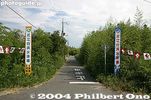
Entrance to Omi-Shirahama BeachAug 26, 2008
|
|

Adogawa RiverAug 26, 2008
|
|

Aug 26, 2008
|
|

Adogawa also has a shoreline road and cycling road. This is how it looks. Entering Adogawa from Shin-Asahi.Aug 26, 2008
|
|
| 995 files on 4 page(s) |
 |
3 |
|