 Most viewed - Mt. Shizugatake 賤ヶ岳 Most viewed - Mt. Shizugatake 賤ヶ岳 |
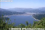
Lake Yogo as seen from Mt. Shizugatake in Nagahama, Shiga. This is in May.262 views
|
|

Great views of northern Lake Biwa as seen from Mt. Shizugatake.240 views
|
|
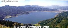
Lake Yogo as seen from the hiking trail on Mt. Shizugatake in Nagahama, Shiga Prefecture.236 views
|
|

From the train approaching JR Kinomoto Station on the Hokuriku Line, you can see the chair lift trail on the slope of Mt. Shizugatake. To reach Shizugatake from Kinomoto Station, take a bus bound for Sugaura (菅浦) or Shindono (新道野).200 views
|
|

Northern Lake Biwa, looking toward Sugaura. Seen from Mt. Shizugatake.128 views
|
|
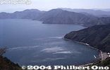
123 views
|
|

Shimmering waters of Lake Biwa.121 views
|
|

Marker for the Battle of Shizugatake and the famous "Seven Spears" which refer to Hideyoshi's top generals in the battle.118 views
|
|

That's Chikubushima island on the left.116 views
|
|

Samurai statue on Mt. Shizugatake114 views
|
|

The defunct Yogoko-so Kokuminshuku lodge at the southern tip of the lake. It had a scenic view of the lake. This was a national pension with affordable prices. 国民宿舎 余呉湖荘105 viewsSadly, after 40 years in business, this pension closed in Sept. 2013 due to aging facilities that were too expensive to repair. It has been torn down.
|
|

At the end of this trail is this shore of Lake Yogo, on the opposite end from Yogo Station. You still have to walk along one side of the lake to get to the train station. It's a scenic walk.105 views
|
|

98 views
|
|

Another trail from the summit of Shizugatake is next to this lookout deck. 94 views
|
|
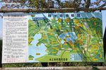
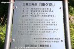
Map of Shizugatake and Yogo area.92 views
|
|

At the top of the chair lift. Mt. Shizugatake chair lift (500 meters long) started operating in Aug. 1959. It takes 6 minutes to go up to the top.90 views
|
|

Lookout deck for the south.89 views
|
|

Mt. Shizugatake chair lift costs ¥450 one way, or ¥900 round trip (as of Jun 2021). If you plan to hike down to Lake Yogo (recommended), buy a one-way ticket.88 views
|
|

About the Battle of Shizugatake.87 views
|
|

From the parking lot, there is a short path to the chair lift.86 views
|
|

Chair lift going to Mt. Shizugatake. This lift operates April-Nov., 9 am - 5 pm. Closed during winter.86 views
|
|

Get off at the Ooto (大音) bus stop as seen here, and cross the road and walk toward the mountain. 84 views
|
|

You can see white banners on the top of Shizugatake.84 views
|
|

A small shrine dedicated to the warriors who died at battle on the mountain.84 views
|
|

84 views
|
|

Near the summit are the white banners we saw from the foot of the mountain. They are written with the names of Hideyoshi's so-called "Seven Spears," in reference to his top seven samurai generals who went to battle at Shizugatake.83 views
|
|
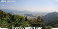
On this side of Shizugatake is a great view looking south.83 views
|
|

View looking south.83 views
|
|

Sign pointing the way to Shizugatake. MAP82 views
|
|

The seven generals were Fukushima Masanori (1561-1624), Hirano Nagayasu (1559-1628), Kasuya Takenori (1562-1607), Katagiri Katsumoto (1556-1615), Katō Kiyomasa (1562-1611), Katō Yoshiaki (1563-1631), and Wakizaka Yasuharu (1554-1626).82 views
|
|

A small shrine along the way.80 views
|
|

80 views
|
|

79 views
|
|

After you get off the chair lift, walk up the slope for 300 meters to the summit.78 views
|
|

Lookout deck for Lake Yogo.77 views
|
|
77 views
|
|

76 views
|
|

On the other side of Shizugatake is this lookout deck.75 views
|
|

Dense forest, somewhat rocky at times. Go right here.75 views
|
|

74 views
|
|

74 views
|
|

74 views
|
|

73 views
|
|

In the lookout deck is this board to hang votive tablets on which people write their wishes.73 views
|
|

Older votive tablets which were removed from the wall are preserved as photos in this photo album.73 views
|
|

View of Nagahama.73 views
|
|

72 views
|
|

Yogo mountains72 views
|
|

Lake Yogo as seen from Mt. Shizugatake. This is in Sept. Looks greenish due to algae perhaps. Been like that since Aug. It turns blue again in fall.72 views
|
|

This trail is the shortest route to Lake Yogo. It goes down to the Yogo-so minshuku.72 views
|
|
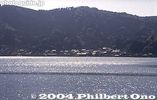
Lake Yogo72 views
|
|

71 views
|
|

71 views
|
|

Another worn out monument on Shizugatake.70 views
|
|

70 views
|
|

70 views
|
|

70 views
|
|

Hiking trail to Lake Yogo.70 views
|
|

69 views
|
|

69 views
|
|

Summit of Shizugatake. A small flat clearing.68 views
|
|

At one end of the summit area is a hiking trail leading to the far end of Lake Yogo, toward Yogo Station. The trail is 3.9 km.67 views
|
|

Lake Yogo gets closer toward the end of the trail.67 views
|
|

66 views
|
|

66 views
|
|

The trail is heavily wooded, and sometimes there is a clear area where you can see the scenery.65 views
|
|
|
|
|
|