 Image search results - "ocean" Image search results - "ocean" |

Boat for Taketomi at Ishigaki Port.
|
|

Kondoi Picnic Site
|
|

Meoto-Iwa Wedded Rocks off the coast of Futami-cho, Ise city, Mie Prefecture. 夫婦岩
|
|

Kondoi beach
|
|

The Wedded Rocks are part of Futami Okitama Shrine known for frog sculptures. 二見興玉神社
|
|

Be aware that these parasols are not free.
|
|

The shrine is dedicated to Sarutahiko and Ukano-mitama. Sarutahiko is a god which serves as a pathfinder guide. Deities for land/sea transportation safety. 二見�
|
|

Kondoi beach
|
|

The frog is Sarutahiko's messenger. Frog is called "kaeru" in Japanese, which is a homonym for the another word meaning "return home." If you travel a lot, pray here for a safe return. 夫婦岩
|
|

Futami Okitama Shrine does not have a main hall (Honden) like most other shrines. It worships the Okitama Sacred Stone in the ocean beyond the Wedded Rocks. 二見興玉神社
|
|

Lantern and sunset at Futami Okitama Shrine
|
|

Sunset at Futami Okitama Shrine. In the old days when traveling was a hazardous undertaking in Japan, pilgrims who traveled to worship at the Ise Grand Shrines prayed here for a safe return home.
|
|

Hoshi Sunahama or Star Sand Beach
|
|

Seto Inland Sea as seen from Megishima, Kagawa Pref.
|
|

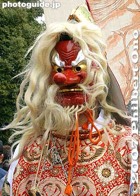
Men carry spanking-new shimenawa ropes to the rocks.
|
|

The Wedded Rocks are actually a type of torii gate for worshipping the Okitama Sacred Stone in the ocean.
|
|

The torii on the larger rock is quite small. The sacred rope is replaced three times a year on May 5, September 5, and at the end of December.
|
|

5月5日、9月5日と12月下旬には夫婦岩の大注連縄の張り替え神事が行われる。これらの写真は5月5日に撮影された。
|
|

Looking toward Ogishima in Seto Inland Sea. 男木島
|
|

The men begin to cut off the old rope. Those sharp sickles soon made short work of the old sacred ropes which were brought ashore in small pieces.
|
|

The ceremony attracts a large crowd.
|
|

The shimenawa rope actually consists of five smaller ropes. They cut the ropes one by one.
|
|

The ropes are now completely cut, breaking the bond between the two rocks.
|
|

The old rope is taken away.
|
|

The new ropes are strung across the two rocks. A small rope tied to the end of the large rope is used to pull the large rope up the rock.
|
|

Kasai Kaihin Park beach. It's not Hawaii, but better than nothing. 葛西海浜公園
|
|
|

Baby stingray (dead) beached.
|
|

The first rope is wound around both rocks.
|
|

The second rope is installed.
|
|
|

One by one, the men carefully positioned the new sacred ropes on the two Rocks. All the while, young children and young men are chanting on the shore.
|
|
|
|

Replacing the rope for the Wedded Rocks, Mie Pref.
|
|

Five ropes are being positioned and made taut.
|
|
|

All the while, the cheering section chants and wave streamers.
|
|
|
|
|

Jodogahama sign. Part of the Rikuchu-Kaigan National Park.Rikuchu-Kaigan National Park, Iwate Pref.
|
|

Aoshima in the distance.
|
|

Pieces of the old rope. Anyone could take home the pieces of old sacred rope if they wanted.
|
|

Jodogahama literally means Paradise Beach.Rikuchu-Kaigan National Park, Iwate Pref.
|
|

Bridge to Aoshima.
|
|

Making sure that the rope is aligned and positioned correctly.
|
|

Dramatic rock formations.Rikuchu-Kaigan National Park, Iwate Pref.
|
|

Straight rows of layered rock.
|
|

The job is finished.
|
|

Jodogahama, Iwate Pref.Rikuchu-Kaigan National Park, Iwate Pref.
|
|

Aoshima Shrine torii and Devil's Washboard, Miyazaki
|
|

The rope installers return to shore.
|
|

Not a sandy beach, but still popular in summer.
|
|

Aoshima Shrine torii and Devil's Washboard, Miyazaki 青島
|
|

Wedded Rocks with a new rope. Japan has numerous other Wedded Rocks and stones, but this is by far the most famous.
|
|
|
|
|

Marvelous contrast between the torii and layered rock.
|
|

Close-up of rock
|
|

Aoshima Shrine torii
|
|

Aoshima Shrine torii
|
|
|
|
|

Aoshima Shrine, Miyazaki
|
|

Aoshima's Devil's Washboard
|
|
|

Not my bicycle
|
|

Trail around the island
|
|
|
|

Aoshima from a distance.
|
|

Northern view from Beppu Tower
|
|

Southern view from Beppu Tower
|
|

Now entering Iwami-cho town from Fukui.
|
|

Uradome Coast, Tottori, part of the San-in Coast National Park. 山陰海岸国立公園
|
|

Perfect for snorkeling, Uradome Coast, Tottori
|
|

Uradome Coast, Tottori, part of the San-in Coast National Park. 山陰海岸国立公園
|
|

Uradome Coast, Tottori
|
|

Yumigahama beach, Yonago, Tottori Pref.
|
|

View of bay, Kamaishi, Iwate
|
|

Roadside scenery on Amami-Oshima island, Kagoshima, Japan.
|
|

Scenic coast on Amami-Oshima island, Kagoshima, Japan.
|
|

Amami-Oshima coastal view.
|
|

On Amami-Oshima, Kagoshima, Amami Resort Basyayama-mura beach had pumice that came from an undersea volcano (Fukutoku-Okanoba) erupting near the Ogasawara islands (way south of Tokyo).
|
|

In 2021, an army of volunteers took weeks to clean up Okinawan and Amami beaches. It was almost like cleaning up an oil spill. Glad the problem has subsided.
|
|

Pumice pebbles on a beach in Amami-Oshima, Kagoshima, Japan.
|
|

Cape Ayamaru sign and photo spot, Amami Oshima, Kagoshima.
|
|

Lookout deck at Cape Ayamaru with views of the coral reef and ocean. Amami Oshima, Kagoshima.
|
|

Lookout deck at Cape Ayamaru shows a beautiful aqua-blue ocean.
|
|

Otaru in sight from the train window.
|
|

View of Seto Inland Sea from Mt. Fudekage in Mihara, Hiroshima. you can see Kosagi in the foreground, Sagi, and Hoso islands. In the distance on the right is Innoshima and part of the Shimanami Kaido bridge connecting Shikoku (Imabari) and Hiroshima.
|
|

Kita-Ibaraki is a small, coastal city (pop. 42,000) with these picturesque cliffs of the Izura Coast (五浦海岸). Famous art scholar Okakura Tenshin (1863–1913 岡倉天心) found this scenic place to be a great inspiration for artists and moved here
|
|

The small red pavilion is Izura Rokkakudo (五浦六角堂), the symbol of Kita-Ibaraki. Izura Rokkakudo was originally designed and built in 1905 by artist Okakura Tenshin (岡倉天心) as part of his residence. His house is on the left..
|
|

Artist-inspiring scenery around Rokkakudo, Kita-Ibaraki.
|
|

Kabira Bay on Ishigaki, perhaps the island's most famous tourist spot. Glass bottom boats to see coral and tropical fish in shallow water.
|
|

Kabira Bay, Ishigaki. It's actually a large bay and this is only a small part of it. Scenic with white beach, blue ocean, small islands and coral on the bottom.
|
|

Parrot fish in Kabira Bay.
|
|

While walking here, I looked down since my intuition told me I might find something...
|
|

Sure enough, a well-disguised starfish moving in slow motion. Hope it's not the kind that eats coral or other native species. Kabira Bay, Ishigaki.
|
|

Amanohashidate is northern Kyoto's main attraction and very famous for centuries as one of Japan's Scenic Trio (Nihon Sankei 日本三景). The other two in the scenic trio are Miyajima (vermillion torii and shrine on the ocean) in Hiroshima and Matsushima (pine tree islands) near Sendai, Miyagi Prefecture. It's about 3.6 km long, totally flat, and you can cross it on foot or by bicycle (rentals available) on a dirt road in the middle. The road is lined with thousands of Japanese pine trees and closed to vehicular traffic. This view is from the northern end atop Kasamatsu Park. Near Amanohashidate Station.
|
|

The thing about Amanohashidate is that it looks very different from different lookout points. The most popular spots to view Amanohashidate are on the hilltop on the southern end and northern end.If you have time, I highly recommend that you see it from both the southern end and northern ends. Which means you should rent a bicycle and ride across Amanohashidate.
This is from the hilltop on the southern end, from a small amusement park called Amanohashidate Viewland easily accessible via chair lift or cable car, and a short walk from Amanohashidate Station. Map: https://goo.gl/maps/yNhxjwK2ocz
This southern end connects to mainland Japan, so what you see in the distance is Tango Peninsula up north.
The left side is the west side with an enclosed, but connected ocean named Asoumi Sea. The right side is the east side with white-sand beaches facing the open ocean. Ships can still go through both sides of the sandbar through a narrow strait on the southern end.
The greenery area on the lower left facing the sandbar is Chionji Temple.
|
|

Tango Peninsula in northern Kyoto Prefecture is scenic along the coast with a number of natural features and formations.Much of the coast is part of the San'in Kaigan Geopark (山陰海岸ジオパーク) that extends from the western half (Kyotango city) of Tango Peninsula to Tottori Prefecture. San'in Kaigan Geopark is also a UNESCO Global Geopark.
|
|

These photos were taken while cycling along the Tango Peninsula.
|
|

Tango Peninsula coast.
|
|

Tango Matsushima (pine islands).
|
|

Tango Matsushima (pine islands).
|
|

Tateiwa Rock on the Tango Peninsula, northern Kyoto. The swimming beach leading to Tateiwa is named Tateiwa Nochigahama (立岩後ヶ浜海水浴場).
|
|

Tateiwa Rock on Tango Peninsula.Map (Tateiwa): https://goo.gl/maps/QDHmG1qArez
|
|

Sengan Pine tree on a craggy rock on Morito Coast. Part of Morito Daimyojin Shrine in Hayama, Kanagawa. 千貫松
|
|

Chirihama Nagisa Driveway in Hakui, Ishikawa is Japan's only beach where motor vehicles are permitted to run as a public thoroughfare. It extends for about 8 km. It goes parallel to another highway inland, so this beach road is more for tourists. Note that this beach may be closed to traffic in bad weather.
|
|

Even tour buses can easily drive on the beach. One of the coolest things I ever saw in Japan.Chirihama Nagisa Driveway in Hakui, Ishikawa.
|
|

The sand grains are about half the size of normal sand, resulting in a very packed and solid sandy surface. Solid enough for vehicles.Chirihama Nagisa Driveway in Hakui, Ishikawa.
|
|

Senmaida in Shiroyone, Wajima is one of Japan's most famous terraced rice paddies. It's in a remote location (10 km from central Wajima), but very picturesque with the ocean (Sea of Japan) right below it. Senmaida literally means "One-thousand rice terraces."
|
|

Volunteers plant and harvest the rice here. The rice paddies are owned by multiple owners who meet ownership requirements.
|
|

Beach volleyball courts. Should come back in summer.
|
|

Onjuku Beach is a wide, expansive beach. 御宿海岸
|
|

When it's windy, the sand flies.
|
|

Onjuku Beach
|
|
|
|
|
|
|

Windsurfing at Onjuku
|
|
|
|

The beach sand is very fine.
|
|

A few hotels overlook the beach.
|
|

Monument for "Desert of the Moon," a famous children's song created on Onjuku Beach in 1923 by Kato Masao (加藤まさを). (Tsuki no Sabaku) 月の沙漠
|
|

Looks like a sand dune, but it's solid concrete looking like sand.
|
|

A prince and princess on camels. This monument was built in 1969. 月の沙漠
|
|
|

Princess on camel
|
|
|
|

Onjuku Beach
|
|

Iwase took many precious photos of these young and old hardworking women. He put them in a book called Groups of Women Ama Divers. They were topless because it felt more comfortable.
|
|

There was this scenic spot on Rebun, so we got out of the car and took a look (and swim).
|
|

Amazing how this little island of Rebun can pack so many sights. Must be wondrous when the flowers are in bloom.
|
|

Rebun sunset in Hokkaido.
|
|
|
|

Back on land.
|
|
|
|
|

Festival girls posing for me. They love the attention.
|
|

Kazusa Junisha Matsuri Festival, Ichinomiya, Chiba on Sept. 13, 2009.
|
|

Women standing by to pull the mikoshi.
|
|
|

Tossing the mikoshi into the air.
|
|

I kept shooting their backs. Next time, I'll try to shoot more faces.
|
|

You could go in front of them to shoot their faces, but the water would be deeper.
|
|

They kept waving their fans and cheering in the water.
|
|
|
|

Great spectacle, especially with women included. Great idea to allow women in the festival.
|
|
|

Returning to land.
|
|

The men covered their bellies, while the women covered their bellies and chests.
|
|

This festival separates the amateur photographers from the pros. Amateurs wear long pants and shoes and enter the ocean to take pictures. I was of course wearing shorts and rubber slippers (but barefoot in the water).
|
|

The next spectacle was them running through the torii on the beach.
|
|

The Sands of Tottori. Every prefecture has something nationally (and sometimes internationally) famous. In the case of Tottori, it's definitely the sand dunes (sakyu in Japanese).It's on the beach facing the Sea of Japan. The dunes were formed by the ocean currents that deposited the sand on the coast for 100,000 years or so. I find that amazing since most of the beaches I know have the ocean currents eat away the sand.
|
|

The San'in coast has lots of little islands and rocks. This is Japan's No. 1 sand dunes for tourists. Quite white and convenient to get here.
|
|

The sand dunes can be pretty steep, but not dangerous. They have downhill sand boarding.
|
|
|

Over many years, strong winds blew the ocean sand onto the beach to form the Tottori Sand dunes.
|
|

Very dramatic ocean at Tottori Sand Dunes.
|
|

Tottori beach near the Chiyo River.
|
|
|

Hakuto Beach, famous for the folktale about a white rabbit crossing the ocean on crocodile backs.
|
|

Uomidai Lookout Point 魚見台
|
|

On the northern tip of Iriomote is scenic Hoshi-suna Beach. Famous for star-shaped sand grains, but hard to find. 西表 星砂の浜Map here
|
|

Iriomote Hoshizuna Beach.
|
|

Yakushima's Miyanoura Port has nice mountain views when it's not foggy/rainy.
|
|

Kannonzaki Park juts into Uraga Channel, the mouth of Tokyo Bay. It is a large park on a cape with walking paths and a lighthouse. 観音崎公園
|
|

Kannonzaki Park
|
|

The shore is rocky.
|
|

Lots of ships pass by here.
|
|
|
|

Cape Kannonzaki is at the tip closest to Uraga Channel, the narrow mouth of Tokyo Bay. Ships must pass through here to enter or depart Tokyo Bay.
|
|

Container ships, oil tankers, passenger ships, navy ships, etc., all pass through here. Anybody have a picture of an aircraft carrier passing by here?
|
|

If you like ship watching, come to Kannonzaki. This is the Nippon Maru cruise ship. にっぽん丸豪華クルーズ船
|
|

Lookout point at Kannonzaki Park.
|
|
|

Looks like the devil's washboard.
|
|
|

Walking path around Kannonzaki.
|
|

Types of ships that pass by.
|
|

Map of Kannonzaki drawn by Commodore Perry when he first arrived in 1853.
|
|
|

Kurihama in the distance.
|
|
|

More ships
|
|

Kurihama in the distance.
|
|
|
|
|

Tatara-hama Beach
|
|

Manta Beach on Yubu. マンタの浜
|
|

Iriomote mangroves.
|
|

Zushi was developed as a seaside resort from the 1960s. Celebrities who had homes here include Shintaro Ishihara, novelist and former Tokyo governor.
|
|
|
|
|
|


