The old Rikuchu-Kaigan National Park (陸中海岸国立公園) along the rocky Tohoku coast centered on Iwate Prefecture whose old samurai provincial name was “Rikuchu.” It extended from the city of Kuji (久慈市) in northern Iwate to Kensen-numa (気仙沼市) in northern Miyagi Prefecture.
On March 11, 2011, the Tohoku Pacific coast was devastated by the big tsunami. After the area was cleaned up, the national park was extended further north to include Hachinohe (八戸市) in southern Aomori Prefecture and renamed “Sanriku Fukko National Park” (三陸復興国立公園) in May 2013. In March 2015, the park was expanded further south from Kensen-numa to include Ishinomaki in Miyagi Prefecture. So the entire coast of Iwate Prefecture is now a national park. Hachinohe to Ishinomaki is about 350 km (217 mi.), about the same distance as Tokyo to Nagoya in Aichi Prefecture.
Park: https://www.env.go.jp/en/nature/nps/park/sanriku/
“Sanriku” (三陸) refers to the old samurai provincial names for Aomori, Iwate, and Miyagi which basically were Rikuo, Rikuchu and Rikuzen. (The three “Riku” provinces.) And “Fukko” (復興) means “recovery” in reference to the March 2011 disaster. It seems the Japanese government likes to pretend that the area has recovered by creating all these “Recovery” monikers (“Recovery Olympics” is another one). However, the region is still far from a full recovery, if that is even possible.
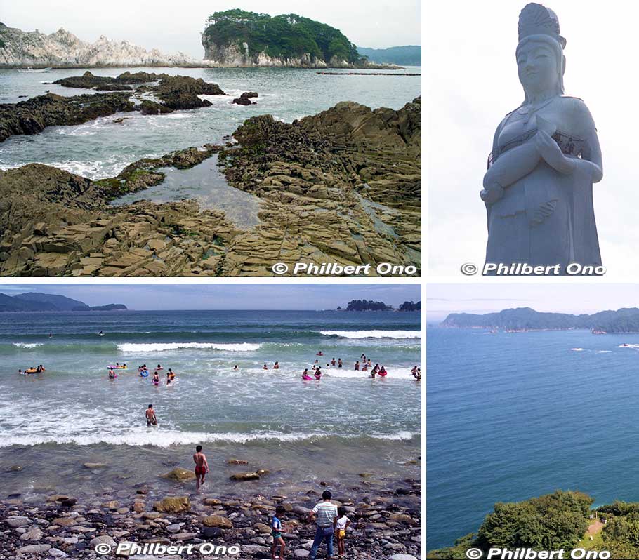
The national park has a dramatic, rocky coast. I visited years before the 2011 tsunami and had only a day to ride the Sanriku Railway from Miyako Station to Kamaishi Station to see a few sights along the way. I got off at stations which were near the ocean. Near Miyako Station by bus was one major sight, Jodogahama (浄土ヶ浜) with craggy rock formations (upper left photo) and a rough beach. It’s also part of the Sanriku Geopark.
My next stop (lower left photo) was Namiita Beach (浪板海岸) near Namiita Kaigan Station (浪板海岸). Very rocky beach, but a nice summer retreat for the locals. My last stop on the coast was Kamaishi which was also badly hit by the tsunami. When I visited, little did I know that the city would be devastated years later.
In Kamaishi, one outstanding sight is the giant Kamaishi Dai-Kannon statue (釜石大観音) looking out at the sea (upper right photo). Built with ferroconcrete by a local Soto Zen Buddhist temple on April 8, 1970, it stands 48.5 meters high on a hill. You can go inside and go up the staircase to the lookout deck on the statue’s left arm and fish. (You can see people there in the upper right photo.) Great views of the waterfront and ocean (lower right photo). Too bad she cannot talk and tell us what she saw on the day of the tsunami.
So why is she carrying a fish? It’s actually a kind of Kannon called “Gyoran Kannon” (魚籃観音) now considered to be a protector for seafarers and fishing. Small admission charged.
Official: http://kamaishi-daikannon.com/
The Sanriku Railway along the coast was severely damaged by the 2011 tsunami and by a typhoon in 2019, but it was completely repaired and restored by 2020.
This national park coast and beyond (into Fukushima) now has a long hiking trail called “Michinoku Coastal Trail” (みちのく潮風トレイル). It’s about 450 km (280 mi.) long as the crow flies between Hachinohe and Soma in Fukushima Prefecture. The trail opened in sections from 2013 until 2019 when the trail was finally completed. I never hiked it, but Jodogahama is one major sight on the trail.
Great way to see the coast. The terrain and scenery are very diverse: pebble beaches, seaside tunnels, craggy rocks, cliffs, paved coastal roads, and forests. You can go in either direction, north to south or vice versa. Detailed maps are sold in book form. It would take weeks to hike the entire trail, so choose which section to hike for the amount of time you have. The trail doesn’t have much signage, so it’s up to you to not get lost. Study the trail before going. Best to hike with someone and not by yourself. ![]()
Michinoku Coastal Trail: http://tohoku.env.go.jp/mct/english/
![]() Nearest station to Jodogahama is Miyako Station on the Yamada Line from Morioka. From Miyako Station, it’s a 20-min. bus ride to Jodogahama. Kamaishi Dai-Kannon is a 10-min. bus ride from Kamaishi Station and 10-min. walk from the bus stop.
Nearest station to Jodogahama is Miyako Station on the Yamada Line from Morioka. From Miyako Station, it’s a 20-min. bus ride to Jodogahama. Kamaishi Dai-Kannon is a 10-min. bus ride from Kamaishi Station and 10-min. walk from the bus stop.