Maps of Shiga
Last updated: Jan. 12, 2012
by Philbert Ono
Here are some English maps of Shiga. Most of them are Google Maps which I created with English placemarks. For the Google Maps, click on the "View Larger Map" link below the map. Then you can see a list of English placemarks in the left column.
These maps are also included in the "About" pages of Shiga's cities and towns (see Municipalities box at page bottom).
Shiga Prefecture Maps
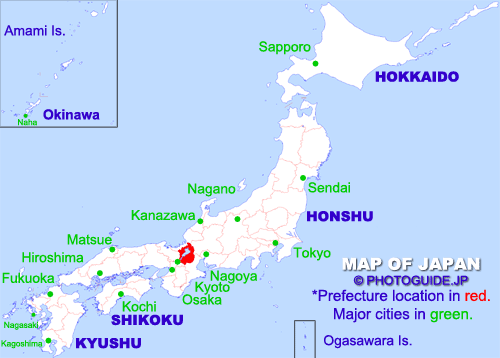
Location of Shiga Prefecture. Almost at the center of the archipelago, Shiga is easy to find on a map of Japan with Lake Biwa (Japan's largest lake) looking like a belly button.
Google Map of Shiga Prefecture. Placemarks in English. Many are illustrated. Click on the "View Larger Map" link below the map to see a list of placemarks. This map mainly shows train stations. More detailed maps and placemarks of each city and town are provided in the respective Google map of the city/town (see map links below).
Shiga City & Town Maps
Google Maps of Shiga cities and towns with English placemarks (so far):
Aisho-cho | Higashi-Omi | Hikone | Hino-cho | Koka | Konan | Kora-cho | Kusatsu | Maibara | Moriyama | Nagahama | Omi-Hachiman | Otsu | Ritto | Ryuo-cho | Taga-cho | Takashima | Toyosato-cho | Yasu
| Municipalities of Shiga Prefecture 滋賀県 | ||
| Cities & Towns: Aisho-cho | Higashi-Omi | Hikone | Hino-cho | Koka | Konan | Kora-cho | Kusatsu | Maibara | Moriyama | Nagahama | Omi-Hachiman | Otsu | Ritto | Ryuo-cho | Taga-cho | Takashima | Toyosato-cho | Yasu | ||
| 愛荘町 | 東近江市 | 彦根市 | 日野町 | 甲賀市 | 湖南市 | 甲良町 | 草津市 | 米原市 | 守山市 | 長浜市 | 近江八幡市 | 大津市 | 栗東市 | 竜王町 | 多賀町 | 高島市 | 豊郷町 | 野洲市 | ||
