 Image search results - "sandbar" Image search results - "sandbar" |

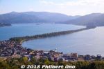
Amanohashidate is northern Kyoto's main attraction and very famous for centuries as one of Japan's Scenic Trio (Nihon Sankei 日本三景). The other two in the scenic trio are Miyajima (vermillion torii and shrine on the ocean) in Hiroshima and Matsushima (pine tree islands) near Sendai, Miyagi Prefecture. It's about 3.6 km long, totally flat, and you can cross it on foot or by bicycle (rentals available) on a dirt road in the middle. The road is lined with thousands of Japanese pine trees and closed to vehicular traffic. This view is from the northern end atop Kasamatsu Park. Near Amanohashidate Station.
|
|

The thing about Amanohashidate is that it looks very different from different lookout points. The most popular spots to view Amanohashidate are on the hilltop on the southern end and northern end.If you have time, I highly recommend that you see it from both the southern end and northern ends. Which means you should rent a bicycle and ride across Amanohashidate.
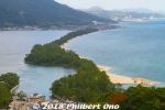
This is from the hilltop on the southern end, from a small amusement park called Amanohashidate Viewland easily accessible via chair lift or cable car, and a short walk from Amanohashidate Station. Map: https://goo.gl/maps/yNhxjwK2ocz
This southern end connects to mainland Japan, so what you see in the distance is Tango Peninsula up north.
The left side is the west side with an enclosed, but connected ocean named Asoumi Sea. The right side is the east side with white-sand beaches facing the open ocean. Ships can still go through both sides of the sandbar through a narrow strait on the southern end.
The greenery area on the lower left facing the sandbar is Chionji Temple.
|
|
|
|
|
|

