 Image search results - "sugaura" Image search results - "sugaura" |

Sugaura is a small settlement in Nishi-Azai along the northern shore of Lake Biwa. It is a quiet and scenic area with a nice lakeshore road and trail almost to the tip of the peninsula. Akasaki Maruko-bune park赤崎丸子船
|
|
|

Some scenery from the road between Nagahara and Sugaura.
|
|

Sugaura is one of the best areas of northern Shiga and northern Lake Biwa. Quiet, clean, and scenic.
|
|
|
|
|
|
|

Large maruko-bune displayed outdoors, without a mast.
|
|

The wooden maruko-bune boat was a common sight on Lake Biwa before railroads were built. They were mainly used for shipping cargo between Kyoto and the northern region of Fukui, Kanazawa, etc.
|
|

Large wooden paddle of a maruko-bune boat. The boat also had a sail. The boat had a round log on both sides.
|
|
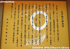
The big maruko-bune boat (17 meters long) was donated by a native of Nishi-Azai. It could hold 13 tons of cargo.
|
|

Lookout point, Chikubushima island in the distance
|
|
|
|
|

Chikubushima island in the distance
|
|
|
|
|
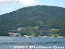
Sugaura as seen from Lake Biwa.
|
|
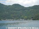
Sugaura as seen from Lake Biwa. The Oku Biwako Parkway Road can be seen going up the mountain.
|
|

The maruko-bune boat is a symbol of Nishi-Azai town which is now part of the city of Nagahama.
|
|

Going down to the lake shore of Sugaura.
|
|

Sugaura is a length-wise town hugging the shore of the lake.
|
|
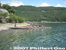
Imazu Junior High School rowers on the shore of Sugaura. They row across the lake between Imazu and Nagahama every summer.
|
|
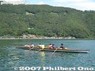
They row in a fixed-seat, wooden boat based on a traditional design circa 1917. Off Sugaura. Oku Biwako Parkway Road going up the mountain.
|
|

Entrance to Sugaura, a quaint lakeshore village on a peninsula. It is will be designated as an Important Cultural Landscape. A pleasant trail goes along the lakeshore trail.
|
|

Thatched-roof gate, called Shisokumon 四足門, on the west end used to monitor outsiders entering the village. Another one is at the east end. MAP
|
|

Suga Shrine, dedicated to Sugaura's patron god. The shrine also has a connection with Emperor Junnin (733-765). 淳仁天皇. 須賀神社須賀神社
|
|

Way to Suga Shrine. Emperor Junnin supposedly once lived in this area in secret.
|
|

Suga Shrine
|
|
|
|

Sugaura Local History Museum 菅浦郷土史料館. Contains historical documents related to the town. But it was closed when I went.
|
|
|

Thatched-roof gate, called Shisokumon 四足門, on the east end used to monitor outsiders entering the village.
|
|

Beyond the east end of Sugaura (beyond the east thatched-roof gate) is a scenic walking trail along the peninsula's shore.After you pass through the town, there is a hiking/bicycle trail along the peninsula.
|
|

Swimming area
|
|

Trail goes further.
|
|

Trail going up the mountain.
|
|

Scenic point at end of trail
|
|
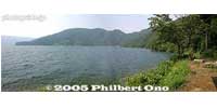
Panorama at end of trail
|
|
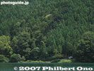
Scenic point at end of trail. Notice the hut.
|
|
|
|
|